

 Isabela State University is in active collaboration with lined government agencies to advance the practices for climate and disaster resilience communities in the widespread advocacy for disaster risk reduction and management (DRRM) in the country.
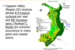
DRRM efforts has now shifted from reactive (response) to a more proactive (prevention and mitigation) mode making geomatics-based flood early warning, monitoring and hazard mapping relevant and timely.
With this, ISU’s research “Lidar-Based Flood Advisory System in Aunugay River Basin, Gonzaga, Cagayan” aimed to elucidate: a smarter DRRM that worked for LGU Gonzaga, Cagayan through river basin-wide LiDAR-based flood advisory system adhering to Industry 4.0 toward digital transformation and use of exponential technologies such as LiDAR, rain guage and water level sensors and internet of things (IoT). Residential buildings, cultivated areas and clay loam soils were mostly affected by floods and increased in magnitude as rainfall volume increased/rainfall return period (RRP) became longer.
Vulnerable communities in consensus with LGU officials proposed and located in the 100-year flood hazard prevention and mitigation map the following structural and non-structural interventions: 500 capacity barangay and 3,000 capacity municipal evacuation centers, watershed and riverbank protection through 200 ha bamboo and tropical fruits plantation, construction of diversion dam in upland barangays, 30 km sea breaker along coastal barangays, change in planting calendar, livestock raising and flood early warning system using existing rainguages and automatic water level sensor.
View Full Text of the Research Gist: Lidar-Based Flood Advisory System in Aunugay River Basin, Gonzaga, Cagayan